|
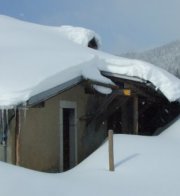
Farms of the Jura in winter The Jura mountains run in a southwest-northeast direction along the border between France and Switzerland, from Geneva (Genève) to Basel (Bâle), holding at about 1300-1400 meters altitude (4350-4500 feet), and peaking in the range of 1650 meters (5450 feet). These photos of high alpage farms in winter are mainly from the southwestern end of that range, between the cities of Geneva and Vallorbe.
Pré de St-Livres
11 April 2004, with the ski club hut just visible above the upper chimney.
11 April 2004, seen from near the Glacière de St-Livres
Looking towards Mondisé and Correntine. 11 April 2004. The village of St-Livres is down by the lake, near Aubonne.
Still 11 April 2004, from the south
The ski-club hut overlooking Pré de St Livres from the ridge above, 31 March 2001 (at 1548m on the map below).
Hut overlooking Pré de St Livres, 31 March 2001.
Pré de St-Livres farm from the ridge above, 31 March 2001, Lake Geneva in the background.
Pré de St-Livres farm from the ridgeline above, May 2001.
The hut seen from Pré de St-Livres, 3 April 2005
from SwitzerlandMobility (http://map.schweizmobil.ch/?lang=en)
19 April 2009
|
Farms of the Jura in winter |
More farms of the Jura |
 Dwight
Peck's farm photos


