|
Farms of the Jura in winter The Jura mountains run in a southwest-northeast direction along the border between France and Switzerland, from Geneva (Genève) to Basel (Bâle), holding at about 1300-1400 meters altitude (4350-4500 feet), and peaking in the range of 1650 meters (5450 feet). These photos of high alpage farms in winter are mainly from the southwestern end of that range, between the cities of Geneva and Vallorbe.
Les Pralets
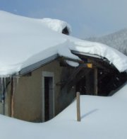
Les Pralets, in addition to its specialties of fromage dishes, is also a working farm in the summer, of course. On this day, 4 January 2003, the proprietor seemed just to have had himself driven up the road in a 4x4 as the first serious snow of the winter began to close the place off.
Passing les Pralets, January 2003, having peeked in the window and given the proprietor a bit of a startle apparently.
Leaving Les Pralets, January 2003; Mont Sala would be visible up to the right, if anything were.
Heading away from Les Pralets towards the car, wherever it may be lurking some ways farther down the hill.
from SwitzerlandMobility (http://map.schweizmobil.ch/?lang=en)
|
Farms of the Jura in winter |
More farms of the Jura |
 Dwight
Peck's farm photos


