You may not find this terribly rewarding unless you're included here, so this is a good time for casual and random browsers to turn back before they get too caught up in the sweep and majesty of the proceedings and can't let go.
Near La Bassine, 30 April 2017

We're starting up a long skinny combe parallel to the road at the top of the Route des Montagnes.

The idea is to look again for an interesting cave stuck up on the rock walls of the combe, somewhere along here.

It's been some years since we've visited here, but surely it's still right where it's always been. Wherever that is.

Not yet.


Up to another level. It can't be far.

Bingo


A mighty jigsaw puzzle piece, right out of the roof

Further explorations for another day, perhaps

We resume our walk.
.
The farm of La Bassine from the southeast; the Combe des Amburnex -Marchairuz road is on the far side.


An anthill hung up on the barbed-wire

A typical mess left by a pre-dawn party of wild boars (sangliers)
Mont Sâla in a vile rain, 7 May 2017

-- There's still time to rethink this.
At the top of the Route des Montagnes (1262m) from Bassins up to La Bassine and the road to Marchairuz.

Wet feet

Up the Bois de la Bassine through the notch path towards the Combe des Begnines

Dripping forests

The winter's damage


At the top of the path (1400m) entering the Combe des Begnines

Up a little combe southwest of the Combe des Begnines

Approaching Mont Sâla's northern end

The beginning of the path up to the summit cross

Persistence

The last bit to the top

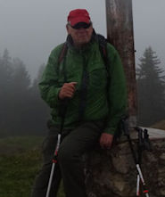
Relaxing by the Mont Sâla summit cross (1510m)

Very wet

A little hole in the hillside, due north of the cross

Further explorations for another day, perhaps

The "Cabane des Electriciens (Commune du Chenit)" at 1471m, just northwest of the summit

Sinkholes all along the Combe des Begnines

Muddily passing the farm of Le Couchant, 1443m

Looking northeastward along the Combe des Begnines

The signpost where the notch path starts down

The farm of Les Begnines (1465m), the middle one of the three in the 2.5km long Combe des Begnines

But we're going somewhere else today

We're walking northeastward between the Combe des Begnines and the parallel long line of cliffs and steep forests above the Combe des Amburnex.

A vestigial path that unfortunately goes nowhere. There are two official ways and one known but unofficial way down from the Combe des Begnines, but we're looking for another still undiscovered.

The end of that path, overlooking the forest below

A potential wet way down that we will not take

Continuing our search for a pleasant way down

Nothing's working out so far. We'll give it up until next time.

Out onto the Combe des Begnines again -- an impediment

But hurdles exist to be got over.

Progressing slowly

In the Combe des Begnines halfway along between the second and third chalets

The third chalet walking northeastward, the Petite Chaux, 1410m

Nearing the northeastern end of the Combe des Begnines

Sinkholes

Down the second of the signposted paths to the ground floor

Below the line of steep forest, now at 1300m, we're returning southward towards the farm of Rionde Dessus, at 1326m on the little hilltop near the left-centre of the photo.

Passing the farm of La Bassine on the Amburnex road

The little carpark at the top of the Route des Montagnes, whence we began.
 Dwight Peck's personal website